
Bridgewater Township Street Directory Steps
A street-by-street search should establish the road and parcel before it searches a name. Bridgewater’s official maps help confirm a street’s spelling and municipal placement. The county parcel viewer then supplies the property geography needed for a tax or deed follow-up. Its public redesign redacts owner names, so the map is a starting point rather than a resident list. Preserve the address exactly as entered, along with the municipality, map date, block and lot, and property class. Those details let a later researcher repeat the same search without turning a dated record into a claim about current occupancy.
- Check the address against the Bridgewater Township map collection. A street map checks the road; zoning, fire, and election maps describe different geographic layers.
- Use the Somerset County Tax Parcel Viewer to find the parcel by address, block and lot, or property class. Record the parcel fields and map date.
- Ask the Bridgewater Tax Assessor office for the relevant property or tax-list information when a defined year and block/lot are known. The official page recommends in-person review for detailed property information.
- Search the legal description or block/lot in Somerset County Clerk Land Records through Acclaim, then note each instrument’s date and parties.
- For an election-record question, use the individual NJ voter registration check or contact the county election office about the controlled voter-list request process. Neither route creates a public street roster.
These steps keep the Bridgewater Township address search tied to sources that are actually keyed by address. A tax entry can identify an owner or mailing address for its tax year. A deed can identify parties to a transfer. A voter record is a registration record with its own restrictions. Each answer must retain its date and record type.
Note: A parcel boundary, a deed party, and a registration record answer different questions, even when they use the same street address.
Bridgewater Township Street Map Fields
The county viewer is a strong geography tool for a Bridgewater Township street search. It offers address, block/lot, and property-class inputs, plus parcel mapping, reports, bookmarks, basemaps, and a 200-foot notification tool. The viewer does not expose a ZIP filter, and its redesigned public data redacts owner names. Use it to translate a street address into a parcel identifier, not to fill an empty owner field from another source.
| Viewer field or tool | Use in a street search | Important limit |
|---|---|---|
| Address | Locates a mapped parcel from a street address. | Confirm the municipality and source date. |
| Block/lot | Creates a stable bridge to tax and Clerk records. | It identifies property geography, not a household. |
| Property class | Provides the viewer’s parcel classification context. | It does not name an occupant. |
| 200-foot tool | Supports nearby-parcel or bounded map analysis. | Distance on a map is not a people list. |
| Reports and maps | Preserve the geographic result for later comparison. | Owner names are redacted in the public viewer. |
Bridgewater Township covers rural, suburban, commercial, and historic areas. The township About page describes about 32 square miles, while the 2025 Master Plan gives 32.36 square miles in total. Keep the source and measure with any note. A mailing label may also differ from the municipal boundary, so map placement comes before a conclusion about where a street lies.
Bridgewater Township Street Legal Searches
When the parcel viewer stops at a redacted owner field, Acclaim supplies the complementary recorded-instrument route. Its legal-description form accepts lot, block, unit, municipality, freeform legal description, building, and date controls. It also offers name, book/page, instrument-number, document-type, consideration, and record-date routes. The record is an instrument, such as a deed, mortgage, lien, release, or map. It is not a conclusion that a named party now lives at the address.
The Acclaim legal-description search shows the fields used to connect a Bridgewater Township street address to the Clerk’s index.
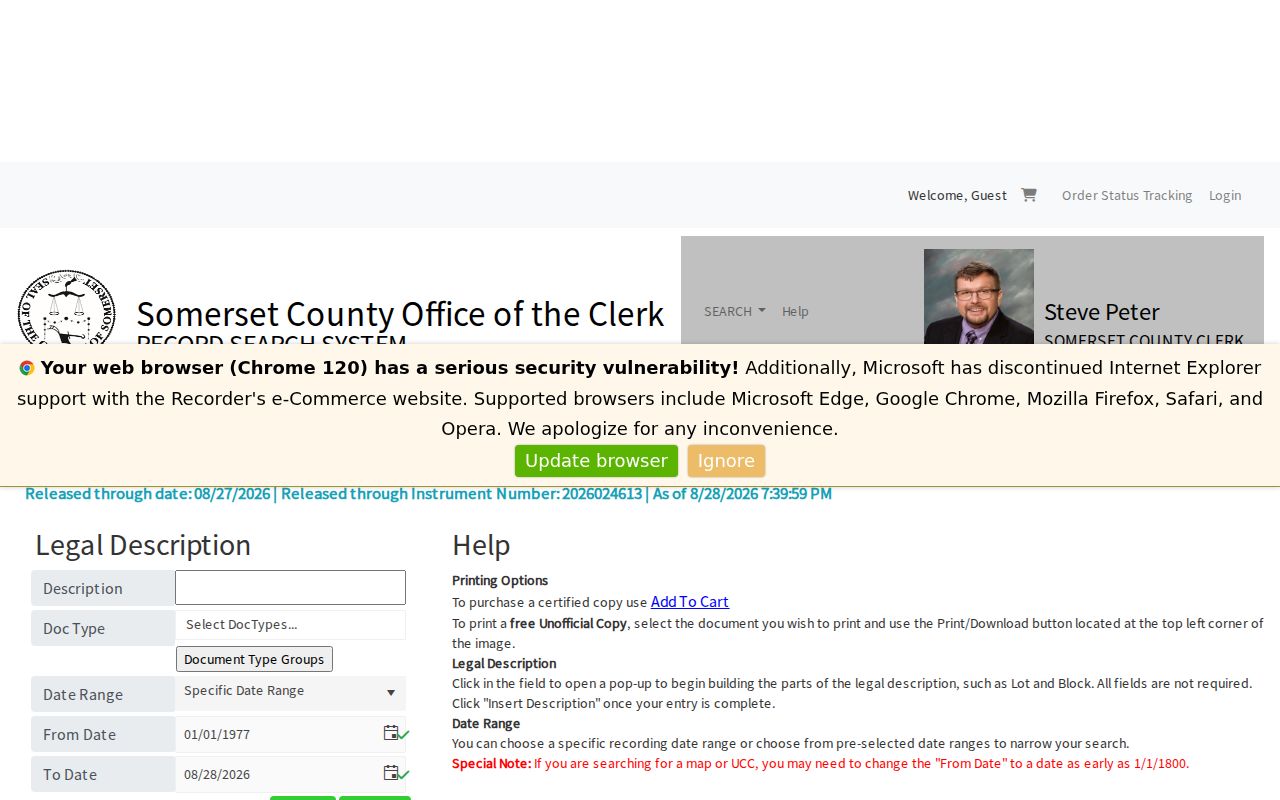
Lot and block information from the map can be carried into this form, then checked against the municipality and date range before any document is reviewed.
Regular index guidance begins on January 1, 1977. For earlier material, the Clerk directs researchers to Acclaim’s Alpha Index, which uses an AZ Volume selector, required last name, and optional first name. Unofficial online images are free after account creation; certified copies have separate charges and can be ordered through the cart or office. The County Clerk cautions that staff do not perform title searches, so a partial index review should never be described as one.
Note: Record the grantor, grantee, document type, recording date, legal description, and image status exactly as the index displays them.
Bridgewater Township Address Records Compared
No one office maintains a complete public list of every person on a Bridgewater Township street. Address records instead divide the work among mapping, tax administration, recorded land instruments, municipal files, and controlled election records. The table separates the initial key from the limited fact a source can establish. It also shows the fallback channels when there is no public name-search page.
| Address record | Best starting key | What it can establish | Access path and limit |
|---|---|---|---|
| County parcel map | Address, block/lot, property class | Parcel geography and map context | Public viewer; owner names are redacted. |
| Tax or assessment record | Defined tax year and block/lot | Tax fields such as property location, owner or mailing information where made public | Assessor, county material, or a focused OPRA request; no public owner portal was located. |
| Recorded instrument | Legal description, block/lot, name, or instrument number | Parties and dated land transaction details | Acclaim index, Records Room, or copy order; not a title opinion. |
| Permit or certificate file | Address, block/lot, file number, type, and date range | A dated municipal application or approval | Code Enforcement or OPRA; no public online permit index was located. |
| Election record | Individual status check or defined election request | Registration status or controlled election material | State check or county election process; not an unrestricted address search. |
The practical bridge is parcel geography. A block and lot can lead from the map to the assessor, tax list, or land index without assuming that an owner, grantee, applicant, or registrant is a current occupant. For municipal records, a precise description and date range make an OPRA request more workable than a request for a newly created street list.
Bridgewater Township Street Address Labels
A Bridgewater Township address search needs four fields kept apart: the situs or property location, mailing address, municipality, and ZIP or post-office label. A deed may give a legal description and a grantee mailing address. A tax list can separate the property location from the tax-bill mailing address. A historic directory might use a nearby town, village, route, or post-office name. Silent normalization can attach the right record to the wrong place.
The 2025 Master Plan identifies 08807 as the principal Bridgewater ZIP and also identifies Martinsville 08836 and Bound Brook 08805 as covering parts of the township. The USPS ZIP Lookup checks a delivery label with street address, city, and state, but USPS says it cannot guarantee a business location. Use the street map or GIS viewer to verify municipal placement instead.
Older sources may also say Finderne, Somerville, Raritan, Martinsville, Bound Brook, or rural route. Copy the source spelling first. Current GIS can help build a crosswalk, but it should not overwrite the historical wording in a deed, directory, or newspaper.
Bridgewater Township Street Permit Files
Street records also appear outside property files. Code Enforcement has forms for construction, alteration, demolition, structural, electrical, plumbing, mechanical, certificate, inspection, use or occupancy, alarm, chimney, and technical-subcode work. Several project types need a plot plan, and the stated process can take up to 20 working days. The research did not locate a public online permit index, so a request should identify the street address, block/lot when known, application or permit number, record type, and date range.
The Township Clerk’s maps distinguish streets from zoning, fire-district, and election-district geography. They can place an address within a governmental layer, but they do not reveal who lives there. Police incident records use an address differently again: an address may be an event location, and the Records Division asks for an incident or case number. Do not combine a permit applicant or incident participant with property ownership unless an independent dated record supports the link.
For a township-held document, Bridgewater NextRequest is the online OPRA route. For county-held material, use the separate Somerset County OPRA process. Both routes work best for an existing, defined record rather than a request to compile a person list.
Note: An applicant, incident participant, or mailing contact is identified only in the dated file that names that role.
Older Bridgewater Township Street Trails
Historic street research has a different sequence. The New Jersey State Archives lists Bridgewater tax-ratable books for 1779, 1781, and 1784 through 1809. A ratable can place a named person in a locality for a stated year, but it is not a modern address directory. The Township’s charter in 1749, incorporation in 1798, and later separation of Somerville and Raritan explain why older records may use a jurisdiction that does not match a current mailing label.
For an earlier address, retain the legal description and parcel clues, then compare the Alpha Index, tax-ratable finding aid, historical maps, newspapers, and local collections. The Somerset County Historical Society holds family files, deeds, maps, correspondence, and other material that can supply an address-era lead. Regional Somerville, Plainfield, and New Brunswick directory runs may help with a historical address, but no Bridgewater-specific city-directory run was located in the reviewed collection descriptions. The collection route is described in more detail on the Bridgewater Township city directory page.
The nearby 1890 Bound Brook church and graveyard Sanborn reference is a useful caution. It does not prove that a Bridgewater sheet exists. Check the precise town and year through the Library of Congress Sanborn collection before treating a map as a house-history source.
Bridgewater Township Street Record Terms
Address research becomes more reliable when the key terms are used narrowly. These definitions describe the record fields that connect a Bridgewater Township street to another official or repository source.
- Parcel
- A mapped piece of real property. In county research, its block and lot can connect the map, tax material, and recorded land files.
- Situs address
- The property’s physical location. It can differ from an owner or grantee mailing address.
- Legal description
- The land description carried in a recorded instrument, often more durable than a street label when names or routes change.
- Plat or map
- A recorded or geographic plan showing land or parcel relationships. It does not establish current occupancy.
- Criss-cross directory
- An address-arranged directory when a verified historical edition supplies one. It must be cited by city, edition, and year.
An address-directory entry should report the smallest supported conclusion, such as “parcel located,” “tax record for a stated year,” or “party to a recorded deed.” That language preserves the difference between a record trail and a household claim.
Bridgewater Township’s 2024 GIS Shift
The 2024 county redesign is the local feature that shapes a modern Bridgewater Township street search. The updated Tax Parcel Viewer added address, block/lot, and property-class filters, browser reports and maps, bookmarks, basemaps, mobile use, and 200-foot tools. At the same time, public owner names were redacted. That combination makes the viewer more useful for parcel geography and less suitable as a direct name source.
Use the map result as a carefully dated handoff to the assessor, tax material, County Clerk, or an appropriately narrow OPRA request. The 200-foot function can identify nearby parcels for a map question, but proximity alone does not show a social or household relationship.
Limits of a Bridgewater Township Street Directory
A deed, tax entry, permit, voter record, or map does not create a public inventory of everyone at an address. The official sources reviewed do not expose a complete historical all-person timeline for a property, public utility customer list, general delivery-address database, or public DMV address search. GIS owner-name redaction is an additional local limit. A missing result can reflect an index boundary, a different jurisdiction, a protected field, or a record that was never created.
Use address records for family history, estate questions, property context, civic research, and other lawful personal purposes. Name the source, date, field, and role. Do not use address records to stalk, harass, intimidate, or harm anyone.
Lawful use. Bridgewater Township address records support personal, lawful research. Never use a map, deed, tax file, or request response to harass, track, or threaten another person.